Geolocate

Cleburne topographic map

Click on the map to display elevation.

About this map
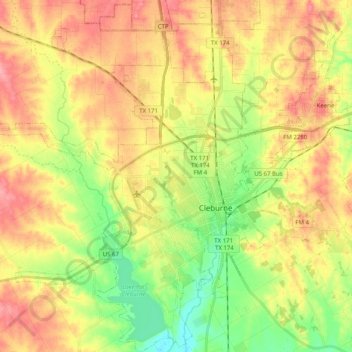
Name: Cleburne topographic map, elevation, terrain.

Location: Cleburne, Johnson County, Texas, United States (32.27795 -97.54567 32.44740 -97.34621)

Average elevation: 833 ft

Minimum elevation: 682 ft

Maximum elevation: 974 ft

Johnson County trails, hiking, mountain biking, running and outdoor activities

Other topographic maps

Click on a map to view its topography, its elevation and its terrain.

Highland

United States > Texas > Johnson County

Average elevation: 650 ft

Turkey Peak

United States > Texas > Johnson County > Burleson

Average elevation: 778 ft

Oak Hill

United States > Texas > Johnson County > Cleburne

Average elevation: 787 ft

Gear up for your next adventure:

🗺️Topographic Maps - Detailed topo maps for hiking, exploring and outdoor navigation
🔦LED Headlamp - Bright and durable LED headlamp for night navigation
🛠️Outdoor Gear Repair Kit - Essential tools to fix gear on the trail
🦶Carbon Trekking Poles - Reduce knee impact on steep descents with ultra-light poles
🎒Outdoor Daypacks - Lightweight backpacks designed for carrying maps and essential gear

As an Amazon Associate, this site earns from qualifying purchases at no extra cost to you.