Geolocate

Cleburne topographic map

Click on the map to display elevation.

About this map

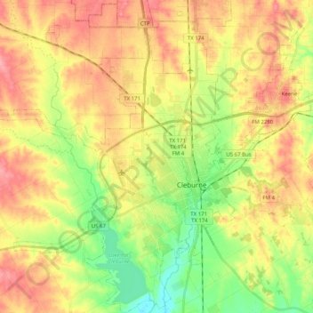
Name: Cleburne topographic map, elevation, terrain.

Location: Cleburne, Johnson County, Texas, United States (32.27795 -97.54567 32.44740 -97.34621)

Average elevation: 833 ft

Minimum elevation: 682 ft

Maximum elevation: 974 ft

Johnson County trails, hiking, mountain biking, running and outdoor activities

Other topographic maps

Click on a map to view its topography, its elevation and its terrain.

Oak Hill

United States > Texas > Johnson County > Cleburne

Average elevation: 787 ft

Turkey Peak

United States > Texas > Johnson County > Burleson

Average elevation: 778 ft

Gear up for your next adventure:

🌡️Portable Weather Meter - Track weather conditions on the trail
📱Heavy-Duty Phone Cases - Drop-proof and waterproof protection for outdoor navigation
Camping Coffee Makers - Enjoy premium coffee at the summit or campsite
Backpacking Tents - Weight-optimized shelters for multi-day topographic surveys
🎒Day Hiking Backpack - Lightweight backpack perfect for day trips and outdoor adventures

As an Amazon Associate, this site earns from qualifying purchases at no extra cost to you.