Geolocate

Southern District topographic map

Click on the map to display elevation.

About this map

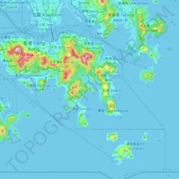
Name: Southern District topographic map, elevation, terrain.

Location: Southern District, Hong Kong Island, Hong Kong, China (22.19265 114.11011 22.27561 114.30905)

Average elevation: 118 ft

Minimum elevation: -20 ft

Maximum elevation: 1,745 ft

Other topographic maps

Click on a map to view its topography, its elevation and its terrain.

Yeung Uk Village

China > Hong Kong

Average elevation: 384 ft

Sunset Peak

China > Hong Kong

Sunset Peak is only accessible by foot. It is located on section 2 of the 70 km (43 mi) long Lantau Trail. Section 2 is 6.5 km long and goes from Nam Shan Campsite west of Mui Wo on South Lantau Road (elevation about 120 m), to Pak Kung Au, another campsite on the Tung Chung Road (elevation about 340 m). Both…

Average elevation: 1,348 ft

大嶺山

China > Hong Kong

Average elevation: 30 ft

Wai Tau Tsuen

China > Hong Kong

Average elevation: 338 ft

Tai Wong Yeh Tun

China > Hong Kong

Average elevation: 315 ft

Tai Leng Pei

China > Hong Kong

Average elevation: 249 ft

Tai Mo Shan

China > Hong Kong

Tai Mo Shan is the highest peak in Hong Kong, with an elevation of 957 metres (3,140 ft) above the Hong Kong Principal Datum [zh], or around 956 metres (3,136 ft) above mean sea level. It is located at approximately the geographical centre of the New Territories.

Average elevation: 1,969 ft

Beacon Hill

China > Hong Kong

Average elevation: 502 ft

Central District

China > Hong Kong

Average elevation: 374 ft

Tsing Chau

China > Hong Kong > Sai Lau Kong

Average elevation: 23 ft

Black Hill

China > Hong Kong

Average elevation: 305 ft

Mountains of Kowloon

China > Hong Kong

Average elevation: 302 ft

Lai Chi Wo

China > Hong Kong

Average elevation: 246 ft

Nam Wai Tsuen

China > Hong Kong

Average elevation: 125 ft

Chung Wong Toi

China > Hong Kong

Average elevation: 371 ft

Por Kai Shan

China > Hong Kong

Average elevation: 715 ft

Mak Uk

China > Hong Kong > Fung Yuen

Average elevation: 292 ft

Tai Wai Village

China > Hong Kong

Average elevation: 430 ft

Nam Wai Tsuen

China > Hong Kong

Average elevation: 125 ft

Wong Chuk Hang San Wai

China > Hong Kong

Average elevation: 381 ft

Sha Po Village

China > Hong Kong

Average elevation: 33 ft

Tseung Kwan O

China > Hong Kong

Average elevation: 236 ft

Victoria Peak

China > Hong Kong

Victoria Peak is a hill on the western half of Hong Kong Island. It is also known as Mount Austin, and locally as The Peak only generally. With an elevation of 552 metres (1,811 ft), it is the tallest hill on Hong Kong Island, and the 29th tallest in the territory of Hong Kong. It is a major tourist attraction…

Average elevation: 686 ft

Kau To

China > Hong Kong

Average elevation: 348 ft

Lan Kwai Fong

China > Hong Kong

Average elevation: 446 ft

Lai Chi Shan Village

China > Hong Kong

Average elevation: 469 ft

Gear up for your next adventure:

🥄Camping Utensil Set - Lightweight utensils for outdoor meals
🧦Merino Wool Socks - Moisture-wicking, blister-preventing socks for long treks
🍳Camping Cook Set - Complete cookware for outdoor meals
🕶️GPS Smartphone Mount - Secure mount for phone navigation
🌧️Backpack Rain Cover - Keep gear dry in wet weather

As an Amazon Associate, this site earns from qualifying purchases at no extra cost to you.