Geolocate

Mooloolaba topographic map

Click on the map to display elevation.

About this map

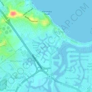
Name: Mooloolaba topographic map, elevation, terrain.

Location: Mooloolaba, Sunshine Coast Regional, Queensland, Australia (-26.69643 153.09686 -26.67380 153.13562)

Average elevation: 23 ft

Minimum elevation: -10 ft

Maximum elevation: 174 ft

Gear up for your next adventure:

🔊Portable Camp Speaker - Music and alerts at camp
🩳Quick‑Dry Hiking Shorts - Comfortable and quick‑dry shorts for summer hiking
🪑Ultralight Camp Chairs - Portable seating for resting after a long day of mapping
😴Insulated Sleeping Pads - Compact and warm pads for high-elevation camping
📷Action Camera - Capture your outdoor adventures in HD

As an Amazon Associate, this site earns from qualifying purchases at no extra cost to you.