
Thank you for supporting this site ❤️
Make a donation
Make a donation
Gear up for your next adventure:
As an Amazon Associate, this site earns from qualifying purchases at no extra cost to you.
Alambadi topographic map
Click on the map to display elevation.
Thank you for supporting this site ❤️
Make a donation
Make a donation
Gear up for your next adventure:
As an Amazon Associate, this site earns from qualifying purchases at no extra cost to you.
About this map
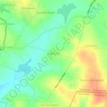
Name: Alambadi topographic map, elevation, terrain.
Location: Alambadi, Maluru taluk, Kolar district, Karnataka, India (12.87305 77.86611 12.91305 77.90611)
Average elevation: 2,877 ft
Minimum elevation: 2,808 ft
Maximum elevation: 2,963 ft
Thank you for supporting this site ❤️
Make a donation
Make a donation
Gear up for your next adventure:
As an Amazon Associate, this site earns from qualifying purchases at no extra cost to you.