
Make a donation
Gear up for your next adventure:
As an Amazon Associate, this site earns from qualifying purchases at no extra cost to you.
Hohe Bracht topographic map
Click on the map to display elevation.
Make a donation
Gear up for your next adventure:
As an Amazon Associate, this site earns from qualifying purchases at no extra cost to you.
Hohe Bracht
Die Hohe Bracht gehört in der naturräumlichen Haupteinheitengruppe Süderbergland (Nr. 33), in der Haupteinheit Südsauerländer Bergland (3362) und in der Untereinheit Südsauerländer Rothaarvorhöhen (3362.5) zum Naturraum Oberlennebergland (3362.52).
Make a donation
Gear up for your next adventure:
As an Amazon Associate, this site earns from qualifying purchases at no extra cost to you.
About this map
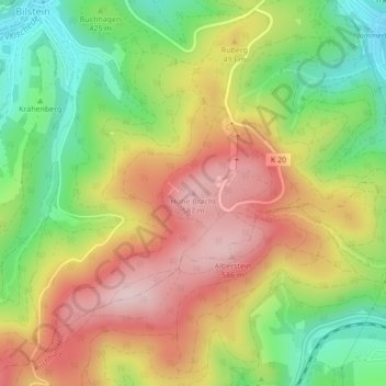
Name: Hohe Bracht topographic map, elevation, terrain.
Average elevation: 1,460 ft
Minimum elevation: 971 ft
Maximum elevation: 1,952 ft
Make a donation
Gear up for your next adventure:
As an Amazon Associate, this site earns from qualifying purchases at no extra cost to you.
Other topographic maps
Click on a map to view its topography, its elevation and its terrain.
Meggen
Deutschland > Nordrhein-Westfalen > Kreis Olpe > Lennestadt
Über Jahrzehnte hinweg wurde die Entwicklung von Meggen stark vom Bergbau beeinflusst. Der Abbau von Schwefelkies in der Umgebung begann in den 1850er-Jahren. Begünstigt wurde die Entwicklung ab 1861 durch den Anschluss an die Lennetalbahn von Hagen nach Siegen und die damit verbundene Verbesserung der…
Average elevation: 1,211 ft