
Bingué topographic map
Interactive map
Click on the map to display elevation.
About this map
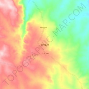
Name: Bingué topographic map, elevation, terrain.
Location: Bingué, Nana-Mambéré, Central African Republic (5.63714 15.20851 5.71714 15.28851)
Average elevation: 2,516 ft
Minimum elevation: 2,070 ft
Maximum elevation: 2,949 ft
Other topographic maps
Click on a map to view its topography, its elevation and its terrain.
Kankan
Central African Republic > Nana-Mambéré
Kankan, Nana-Mambéré, Central African Republic
Average elevation: 3,110 ft
Bouar
Central African Republic > Nana-Mambéré > Bouar
Bouar, Nana-Mambéré, Central African Republic
Average elevation: 2,884 ft