
玛曲县 topographic map
Interactive map
Click on the map to display elevation.
About this map
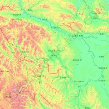
Name: 玛曲县 topographic map, elevation, terrain.
Location: 玛曲县, 甘南藏族自治州, Gansu, China (33.10520 100.76286 34.38453 102.48214)
Average elevation: 12,507 ft
Minimum elevation: 10,843 ft
Maximum elevation: 17,372 ft
Other topographic maps
Click on a map to view its topography, its elevation and its terrain.
日宗
China > Gansu > 迭部县 ཐེ་བོ་རྫོང་།
日宗, 迭部县 ཐེ་བོ་རྫོང་།, 甘南藏族自治州 ཀན་ལྷོ་བོད་རིགས་རང་སྐྱོང་ཁུལ།, Gansu, China
Average elevation: 10,669 ft