
Make a donation
Gear up for your next adventure:
As an Amazon Associate, this site earns from qualifying purchases at no extra cost to you.
Oregon topographic map
Click on the map to display elevation.
Make a donation
Gear up for your next adventure:
As an Amazon Associate, this site earns from qualifying purchases at no extra cost to you.
About this map
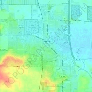
Name: Oregon topographic map, elevation, terrain.
Location: Oregon, Dane County, Wisconsin, 53575, United States (42.90465 -89.42327 42.94306 -89.36512)
Average elevation: 978 ft
Minimum elevation: 922 ft
Maximum elevation: 1,129 ft
Dane County trails, hiking, mountain biking, running and outdoor activities
Make a donation
Gear up for your next adventure:
As an Amazon Associate, this site earns from qualifying purchases at no extra cost to you.
Other topographic maps
Click on a map to view its topography, its elevation and its terrain.
Make a donation
Gear up for your next adventure:
As an Amazon Associate, this site earns from qualifying purchases at no extra cost to you.
Make a donation
Gear up for your next adventure:
As an Amazon Associate, this site earns from qualifying purchases at no extra cost to you.
Walking Iron County Park
United States > Wisconsin > Dane County > Town of Mazomanie
Average elevation: 774 ft
Deansville Wildlife Area
United States > Wisconsin > Dane County > Town of York
Average elevation: 866 ft
Isthmus Path Prairie Garden
United States > Wisconsin > Dane County > Madison
Average elevation: 860 ft
Make a donation
Gear up for your next adventure:
As an Amazon Associate, this site earns from qualifying purchases at no extra cost to you.
Make a donation
Gear up for your next adventure:
As an Amazon Associate, this site earns from qualifying purchases at no extra cost to you.