
Table Bluff topographic map
Click on the map to display elevation.
About this map
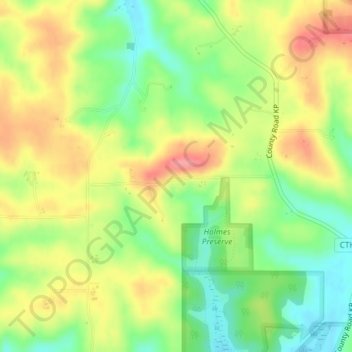
Name: Table Bluff topographic map, elevation, terrain.
Average elevation: 1,004 ft
Minimum elevation: 860 ft
Maximum elevation: 1,158 ft
Dane County trails, hiking, mountain biking, running and outdoor activities
Other topographic maps
Click on a map to view its topography, its elevation and its terrain.
Madison
United States > Wisconsin > Dane County
The city is sometimes described as The City of Four Lakes, comprising the four successive lakes of the Yahara River: Lake Mendota ("Fourth Lake"), Lake Monona ("Third Lake"), Lake Waubesa ("Second Lake") and Lake Kegonsa ("First Lake"), although Waubesa and Kegonsa are not actually in Madison, but just south…
Average elevation: 932 ft
Mount Horeb
United States > Wisconsin > Dane County
Located in Southwest Wisconsin, Mount Horeb is situated in a region referred to as the Driftless Area. While including parts of eastern Minnesota, northeastern Iowa, and northwest Illinois, the Driftless Area is widely regarded as a distinct feature to the Wisconsin landscape, stretching across eighteen…
Average elevation: 1,171 ft
Spring Harbor
United States > Wisconsin > Dane County > Madison > Mendota Beach
Average elevation: 915 ft
Sun Prairie
United States > Wisconsin > Dane County
The landscape of the city consists mostly of gently rolling hills and plains. The elevation of the city averages about 984 feet (300 m) above mean sea level.
Average elevation: 961 ft
Mazomanie Bottoms State Natural Area
United States > Wisconsin > Dane County
Average elevation: 748 ft
Sun Prairie
United States > Wisconsin > Dane County
The landscape of the city consists mostly of gently rolling hills and plains. The elevation of the city averages about 984 feet (300 m) above mean sea level.
Average elevation: 961 ft
Madison
United States > Wisconsin > Dane County
According to the United States Census Bureau, the city has an area of 94.03 square miles (243.54 km2), of which 76.79 square miles (198.89 km2) is land and 17.24 square miles (44.65 km2) is water. The city's lowest elevation is the intersection of Regas Road and Corporate Drive on the east side, at 836.9 ft…
Average elevation: 932 ft
Mount Horeb
United States > Wisconsin > Dane County
Located in southwestern Wisconsin, Mount Horeb is situated in a region referred to as the Driftless Area. While including parts of southeastern Minnesota, northeastern Iowa, and northwestern Illinois, the Driftless Area is a distinct feature of the Wisconsin landscape, stretching across eighteen different…
Average elevation: 1,171 ft
Madison
United States > Wisconsin > Dane County
According to the United States Census Bureau, the city has a total area of 94.03 square miles (243.54 km2), of which 76.79 square miles (198.89 km2) is land and 17.24 square miles (44.65 km2) is water. The city's lowest elevation is the intersection of Regas Road and Corporate Drive on the east side, at 836.9…
Average elevation: 932 ft
Goose Lake Wildlife Area
United States > Wisconsin > Dane County > Town of Deerfield
Average elevation: 876 ft
Madison
United States > Wisconsin > Dane County
According to the United States Census Bureau, the city has an area of 94.03 square miles (243.54 km2), of which 76.79 square miles (198.89 km2) is land and 17.24 square miles (44.65 km2) is water. The city's lowest elevation is the intersection of Regas Road and Corporate Drive on the east side, at 836.9 ft…
Average elevation: 932 ft
Madison
United States > Wisconsin > Dane County
According to the United States Census Bureau, the city has a total area of 94.03 square miles (243.54 km2), of which 76.79 square miles (198.89 km2) is land and 17.24 square miles (44.65 km2) is water. The city's lowest elevation is the intersection of Regas Road and Corporate Drive on the east side, at 836.9…
Average elevation: 932 ft
Walking Iron County Park
United States > Wisconsin > Dane County > Town of Mazomanie
Average elevation: 774 ft
Deansville Wildlife Area
United States > Wisconsin > Dane County > Town of York
Average elevation: 866 ft
Isthmus Path Prairie Garden
United States > Wisconsin > Dane County > Madison
Average elevation: 860 ft
Madison
United States > Wisconsin > Dane County
According to the United States Census Bureau, the city has a total area of 94.03 square miles (243.54 km2), of which 76.79 square miles (198.89 km2) is land and 17.24 square miles (44.65 km2) is water. The city's lowest elevation is the intersection of Regas Road and Corporate Drive on the east side, at 836.9…
Average elevation: 932 ft