
Make a donation
Gear up for your next adventure:
As an Amazon Associate, this site earns from qualifying purchases at no extra cost to you.
Concord topographic map
Click on the map to display elevation.
Make a donation
Gear up for your next adventure:
As an Amazon Associate, this site earns from qualifying purchases at no extra cost to you.
About this map
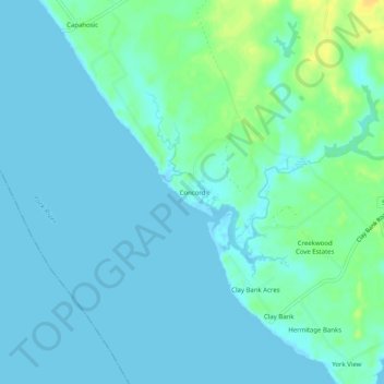
Name: Concord topographic map, elevation, terrain.
Location: Concord, Gloucester County, Virginia, United States (37.34348 -76.63857 37.38348 -76.59857)
Average elevation: 16 ft
Minimum elevation: -7 ft
Maximum elevation: 79 ft
Gloucester County trails, hiking, mountain biking, running and outdoor activities
Make a donation
Gear up for your next adventure:
As an Amazon Associate, this site earns from qualifying purchases at no extra cost to you.
Other topographic maps
Click on a map to view its topography, its elevation and its terrain.
Ware River
United States > Virginia > Gloucester County > Gloucester Courthouse
Average elevation: 10 ft