
Make a donation
Gear up for your next adventure:
As an Amazon Associate, this site earns from qualifying purchases at no extra cost to you.
Newbold on Stour topographic map
Click on the map to display elevation.
Make a donation
Gear up for your next adventure:
As an Amazon Associate, this site earns from qualifying purchases at no extra cost to you.
About this map
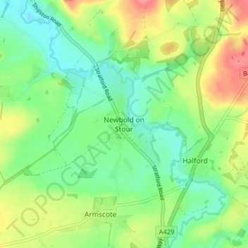
Name: Newbold on Stour topographic map, elevation, terrain.
Average elevation: 226 ft
Minimum elevation: 138 ft
Maximum elevation: 374 ft
Make a donation
Gear up for your next adventure:
As an Amazon Associate, this site earns from qualifying purchases at no extra cost to you.
Other topographic maps
Click on a map to view its topography, its elevation and its terrain.
Bishops Itchington
United Kingdom > England > Warwickshire > Stratford-on-Avon
Average elevation: 341 ft
Priors Hardwick CP
United Kingdom > England > Warwickshire > Stratford-on-Avon
Average elevation: 440 ft
Make a donation
Gear up for your next adventure:
As an Amazon Associate, this site earns from qualifying purchases at no extra cost to you.
Compton Verney CP
United Kingdom > England > Warwickshire > Stratford-on-Avon
Average elevation: 338 ft
Bidford on Avon CP
United Kingdom > England > Warwickshire > Stratford-on-Avon
Average elevation: 138 ft
Upper Lighthorne
United Kingdom > England > Warwickshire > Stratford-on-Avon
Average elevation: 377 ft
Make a donation
Gear up for your next adventure:
As an Amazon Associate, this site earns from qualifying purchases at no extra cost to you.
Stratford-on-Avon
United Kingdom > England > Warwickshire > Stratford-on-Avon
Average elevation: 354 ft
Big Clowes Wood
United Kingdom > England > Warwickshire > Stratford-on-Avon > Tanworth in Arden CP
Average elevation: 499 ft
Make a donation
Gear up for your next adventure:
As an Amazon Associate, this site earns from qualifying purchases at no extra cost to you.
Tanworth in Arden CP
United Kingdom > England > Warwickshire > Stratford-on-Avon
Average elevation: 456 ft
Stratford-upon-Avon
United Kingdom > England > Warwickshire > Stratford-on-Avon
Average elevation: 200 ft
Make a donation
Gear up for your next adventure:
As an Amazon Associate, this site earns from qualifying purchases at no extra cost to you.
Fenny Compton CP
United Kingdom > England > Warwickshire > Stratford-on-Avon
Average elevation: 433 ft
Make a donation
Gear up for your next adventure:
As an Amazon Associate, this site earns from qualifying purchases at no extra cost to you.
Burton Dassett Hills Country Park
United Kingdom > England > Warwickshire > Stratford-on-Avon > Northend > Burton Dassett CP
Average elevation: 433 ft
Stretton-on-Fosse
United Kingdom > England > Warwickshire > Stratford-on-Avon
Average elevation: 354 ft
Make a donation
Gear up for your next adventure:
As an Amazon Associate, this site earns from qualifying purchases at no extra cost to you.
Welford on Avon CP
United Kingdom > England > Warwickshire > Stratford-on-Avon
Average elevation: 144 ft
Oversley Wood
United Kingdom > England > Warwickshire > Stratford-on-Avon > Alcester > Exhall
Average elevation: 210 ft
Make a donation
Gear up for your next adventure:
As an Amazon Associate, this site earns from qualifying purchases at no extra cost to you.
Barcheston
United Kingdom > England > Warwickshire > Stratford-on-Avon > Willington
Average elevation: 269 ft
Burton Dassett CP
United Kingdom > England > Warwickshire > Stratford-on-Avon
Average elevation: 390 ft
Make a donation
Gear up for your next adventure:
As an Amazon Associate, this site earns from qualifying purchases at no extra cost to you.
Pillerton Hersey CP
United Kingdom > England > Warwickshire > Stratford-on-Avon
Average elevation: 302 ft
Make a donation
Gear up for your next adventure:
As an Amazon Associate, this site earns from qualifying purchases at no extra cost to you.
Sutton under Brailes
United Kingdom > England > Warwickshire > Stratford-on-Avon
Average elevation: 433 ft
River Avon
United Kingdom > England > Warwickshire > Stratford-on-Avon > Stratford-upon-Avon > Clifford Chambers
Average elevation: 141 ft
Make a donation
Gear up for your next adventure:
As an Amazon Associate, this site earns from qualifying purchases at no extra cost to you.
Brailes
United Kingdom > England > Warwickshire > Stratford-on-Avon > Lower Brailes
Average elevation: 456 ft
Make a donation
Gear up for your next adventure:
As an Amazon Associate, this site earns from qualifying purchases at no extra cost to you.
Ladbroke (Millennium Green)
United Kingdom > England > Warwickshire > Stratford-on-Avon > Ladbroke CP
Average elevation: 322 ft
Make a donation
Gear up for your next adventure:
As an Amazon Associate, this site earns from qualifying purchases at no extra cost to you.
Make a donation
Gear up for your next adventure:
As an Amazon Associate, this site earns from qualifying purchases at no extra cost to you.
Salford Priors CP
United Kingdom > England > Warwickshire > Stratford-on-Avon
Average elevation: 154 ft
Barton-on-the-Heath
United Kingdom > England > Warwickshire > Stratford-on-Avon
Average elevation: 427 ft
Make a donation
Gear up for your next adventure:
As an Amazon Associate, this site earns from qualifying purchases at no extra cost to you.
Upper Lighthorne
United Kingdom > England > Warwickshire > Stratford-on-Avon
Average elevation: 377 ft
Bidford on Avon CP
United Kingdom > England > Warwickshire > Stratford-on-Avon
Average elevation: 138 ft
Preston on Stour CP
United Kingdom > England > Warwickshire > Stratford-on-Avon
Average elevation: 184 ft
Bishops Itchington
United Kingdom > England > Warwickshire > Stratford-on-Avon
Average elevation: 341 ft
Make a donation
Gear up for your next adventure:
As an Amazon Associate, this site earns from qualifying purchases at no extra cost to you.
Burton Dassett CP
United Kingdom > England > Warwickshire > Stratford-on-Avon
Average elevation: 390 ft
Stratford-upon-Avon
United Kingdom > England > Warwickshire > Stratford-on-Avon
Average elevation: 200 ft
Make a donation
Gear up for your next adventure:
As an Amazon Associate, this site earns from qualifying purchases at no extra cost to you.
Stratford-upon-Avon
United Kingdom > England > Warwickshire > Stratford-on-Avon
Average elevation: 200 ft
Stratford-upon-Avon
United Kingdom > England > Warwickshire > Stratford-on-Avon
Average elevation: 200 ft
Stratford-upon-Avon
United Kingdom > England > Warwickshire > Stratford-on-Avon
Average elevation: 200 ft