
Make a donation
Gear up for your next adventure:
As an Amazon Associate, this site earns from qualifying purchases at no extra cost to you.
Egilsstaðir topographic map
Click on the map to display elevation.
Make a donation
Gear up for your next adventure:
As an Amazon Associate, this site earns from qualifying purchases at no extra cost to you.
Egilsstaðir
Bei Egilsstaðir liegt der Lagarfljót (auch Lögurinn genannt), ein langgestreckter See bzw. gleichnamiger Fluss, in welcher der Legende nach der Lagarfljótwurm, ein Seeungeheuer hausen soll. Unweit von Egilstaður dehnt sich auf einer Höhe von 50–200 m. ü. d. M. mit einer Fläche von 600 ha einer der größten Wälder Islands aus, der Egilstaðaskógur, in dem einige Bäume eine Höhe von 9 m erreichen.
Make a donation
Gear up for your next adventure:
As an Amazon Associate, this site earns from qualifying purchases at no extra cost to you.
About this map
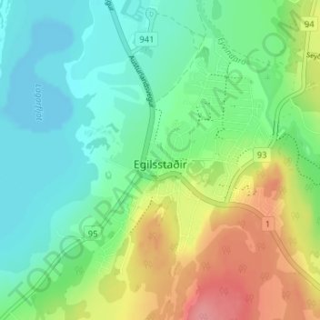
Name: Egilsstaðir topographic map, elevation, terrain.
Location: Egilsstaðir, Múlaþing, Austurland, 700, Island (65.25208 -14.41947 65.27269 -14.37854)
Average elevation: 131 ft
Minimum elevation: 39 ft
Maximum elevation: 305 ft
Make a donation
Gear up for your next adventure:
As an Amazon Associate, this site earns from qualifying purchases at no extra cost to you.