Geolocate

Merbung topographic map

Click on the map to display elevation.

👉 Easily get elevation data in JSON, GeoTIFF and KML formats using Elevation API
Thank you for supporting this site ❤️
Make a donation

About this map

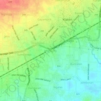
Name: Merbung topographic map, elevation, terrain.

Location: Merbung, Klaten, Central Java, Java, 57424, Indonesia (-7.73729 110.57503 -7.69729 110.61503)

Average elevation: 512 ft

Minimum elevation: 430 ft

Maximum elevation: 623 ft

Other topographic maps

Click on a map to view its topography, its elevation and its terrain.

Kemalang

Indonesia > Central Java > Klaten

Average elevation: 2,769 ft

Jaten

Indonesia > Central Java > Klaten

Average elevation: 384 ft

Bendo

Indonesia > Central Java > Klaten

Average elevation: 361 ft

Sajen

Indonesia > Central Java > Klaten

Average elevation: 344 ft

Bulan

Indonesia > Central Java > Klaten

Average elevation: 394 ft

Depra Sentono

Indonesia > Central Java > Klaten

Average elevation: 335 ft

Pugeran

Indonesia > Central Java > Klaten

Average elevation: 318 ft

Sidorejo

Indonesia > Central Java > Klaten

Average elevation: 3,642 ft

Taji

Indonesia > Central Java > Klaten

Average elevation: 315 ft

RT 11

Indonesia > Central Java > Klaten

Average elevation: 318 ft

Gear up for your next adventure:

🧢Outdoor Hiking Hat - Sun protection hat for outdoor explorers
🩹Survival Bandages - High‑quality bandages for emergencies
🪄Magnetic Compass - Accurate compass for navigation
🗺️Topographic Maps - Detailed topo maps for hiking, exploring and outdoor navigation
🥾Men's Hiking Boots - Durable, waterproof footwear for rugged terrain and steep inclines

As an Amazon Associate, this site earns from qualifying purchases at no extra cost to you.