
Make a donation
Gear up for your next adventure:
As an Amazon Associate, this site earns from qualifying purchases at no extra cost to you.
The Bog topographic map
Click on the map to display elevation.
Make a donation
Gear up for your next adventure:
As an Amazon Associate, this site earns from qualifying purchases at no extra cost to you.
About this map
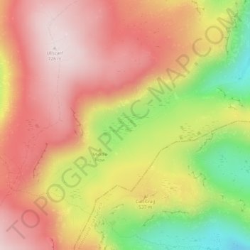
Name: The Bog topographic map, elevation, terrain.
Average elevation: 1,690 ft
Minimum elevation: 686 ft
Maximum elevation: 2,369 ft
Make a donation
Gear up for your next adventure:
As an Amazon Associate, this site earns from qualifying purchases at no extra cost to you.
Other topographic maps
Click on a map to view its topography, its elevation and its terrain.
Make a donation
Gear up for your next adventure:
As an Amazon Associate, this site earns from qualifying purchases at no extra cost to you.
Make a donation
Gear up for your next adventure:
As an Amazon Associate, this site earns from qualifying purchases at no extra cost to you.
Mealsgate
United Kingdom > England > Cumbria > Allerdale > Mealsgate > Fletchertown
Average elevation: 341 ft
Milefortlet 9, Skinburness
United Kingdom > England > Cumbria > Allerdale > Skinburness
Average elevation: 10 ft
Oughterby
United Kingdom > England > Cumbria > Allerdale > Kirkbampton > Oughterby
Average elevation: 115 ft
Make a donation
Gear up for your next adventure:
As an Amazon Associate, this site earns from qualifying purchases at no extra cost to you.