
Thank you for supporting this site ❤️
Make a donation
Make a donation
Gear up for your next adventure:
As an Amazon Associate, this site earns from qualifying purchases at no extra cost to you.
Winkl topographic map
Click on the map to display elevation.
Thank you for supporting this site ❤️
Make a donation
Make a donation
Gear up for your next adventure:
As an Amazon Associate, this site earns from qualifying purchases at no extra cost to you.
About this map
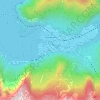
Name: Winkl topographic map, elevation, terrain.
Location: Winkl, Obertraun, Bezirk Gmunden, Upper Austria, 4831, Austria (47.53104 13.66292 47.57104 13.70292)
Average elevation: 2,720 ft
Minimum elevation: 1,634 ft
Maximum elevation: 5,758 ft
Thank you for supporting this site ❤️
Make a donation
Make a donation
Gear up for your next adventure:
As an Amazon Associate, this site earns from qualifying purchases at no extra cost to you.