Geolocate

Lichuan topographic map

Click on the map to display elevation.

About this map

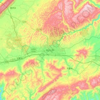
Name: Lichuan topographic map, elevation, terrain.

Location: Lichuan, Lichuan City, Enshi, Hubei, China (30.13374 108.77229 30.45374 109.09229)

Average elevation: 4,242 ft

Minimum elevation: 2,743 ft

Maximum elevation: 6,145 ft

Gear up for your next adventure:

🦶Hiking Gaiters - Keep debris and water out of your boots
📌Outdoor GPS Map App - Apps and devices for digital topographic navigation
📶Satellite Messenger - Communication device off‑grid
🪶Wildlife Field Guides - Learn animal tracking and species ID
🖼️Topo Map Wall Art - Decorative topographic prints of famous peaks and regions

As an Amazon Associate, this site earns from qualifying purchases at no extra cost to you.