Geolocate

Lavasa topographic map

Click on the map to display elevation.

About this map
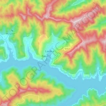
Name: Lavasa topographic map, elevation, terrain.

Location: Lavasa, Mulshi Subdistrict, Pune District, Maharashtra, 412112, India (18.36460 73.46417 18.44460 73.54417)

Average elevation: 2,677 ft

Minimum elevation: 2,054 ft

Maximum elevation: 3,668 ft

Other topographic maps

Click on a map to view its topography, its elevation and its terrain.

Temghar dam

India > Maharashtra > Mulshi Subdistrict

Average elevation: 2,444 ft

Mulshi Dam

India > Maharashtra > Mulshi Subdistrict > Sambhave

Average elevation: 1,995 ft

Shirgaon

India > Maharashtra > Mulshi Subdistrict

Average elevation: 2,257 ft

Gear up for your next adventure:

🎒Trekking Poles - Sturdy poles for balance and stability on rough terrain
🪑Ultralight Camp Chairs - Portable seating for resting after a long day of mapping
👖Convertible Hiking Pants - Versatile zip-off pants for changing altitudes and temperatures
🧥Men's Rain Shells - Premium waterproof and breathable jackets for mountain weather
🕶️GPS Smartphone Mount - Secure mount for phone navigation

As an Amazon Associate, this site earns from qualifying purchases at no extra cost to you.