
Make a donation
Gear up for your next adventure:
As an Amazon Associate, this site earns from qualifying purchases at no extra cost to you.
Blaasveld topographic map
Click on the map to display elevation.
Make a donation
Gear up for your next adventure:
As an Amazon Associate, this site earns from qualifying purchases at no extra cost to you.
Blaasveld
Blaasveld ligt op kleiige en zandige bodem, op een hoogte van 2-5 meter. Het is vastgebouwd aan Willebroek maar heeft ook een landelijk gebied. Het Blaasveldbroek is een 160 hectare groot natuurgebied.
Make a donation
Gear up for your next adventure:
As an Amazon Associate, this site earns from qualifying purchases at no extra cost to you.
About this map
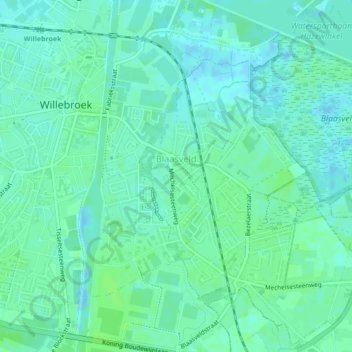
Name: Blaasveld topographic map, elevation, terrain.
Location: Blaasveld, Willebroek, Mechelen, Antwerpen, België (51.04212 4.36785 51.06820 4.40468)
Average elevation: 13 ft
Minimum elevation: -3 ft
Maximum elevation: 26 ft
Make a donation
Gear up for your next adventure:
As an Amazon Associate, this site earns from qualifying purchases at no extra cost to you.
Other topographic maps
Click on a map to view its topography, its elevation and its terrain.