
Mount Elbert topographic map
Click on the map to display elevation.
Mount Elbert
Mount Elbert is composed largely of quartzite. However, the summit ridge consists of metamorphic basement rock, which is Pre-Cambrian in origin and about 1.7 billion years old. There are various igneous intrusions including pegmatite, as well as bands of gneiss and schist. Unlike mountains of similar altitude elsewhere, Elbert lacks both a permanent snowpack and a prominent north-facing cirque, which can be attributed to its position among other mountains of similar height, causing it to receive relatively small quantities of precipitation.
About this map
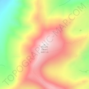
Name: Mount Elbert topographic map, elevation, terrain.
Location: Mount Elbert, Lake County, Colorado, United States (39.11770 -106.44543 39.11780 -106.44533)
Average elevation: 12,989 ft
Minimum elevation: 11,227 ft
Maximum elevation: 14,416 ft
Lake County trails, hiking, mountain biking, running and outdoor activities
Other topographic maps
Click on a map to view its topography, its elevation and its terrain.
Leadville
United States > Colorado > Lake County
The City of Leadville is a statutory city that is the county seat, the most populous community, and the only incorporated municipality in Lake County, Colorado, United States. The city population was 2,602 at the 2010 census and an estimated 2,762 in 2018. It is situated at an elevation of 10,152 feet (3,094…
Average elevation: 10,194 ft
Mount Massive Wilderness
United States > Colorado > Lake County
The Mount Massive Wilderness is a federally designated wilderness area in the Sawatch Range, located in the U.S. state of Colorado. It is operated jointly by the United States Forest Service and the Fish and Wildlife Service as part of the San Isabel National Forest and the Leadville National Fish Hatchery. It…
Average elevation: 11,260 ft
Leadville
United States > Colorado > Lake County
Leadville (/ˈlɛdvɪl/ LED-vil) is a statutory city that is the county seat of, the most populous community in, and the only incorporated municipality in Lake County, Colorado, United States. The city population was 2,633 at the 2020 United States census. It is situated at an elevation of 10,119 feet (3,084…
Average elevation: 10,194 ft
Leadville
United States > Colorado > Lake County
The City of Leadville is a statutory city that is the county seat, the most populous community, and the only incorporated municipality in Lake County, Colorado, United States. The city population was 2,602 at the 2010 census and an estimated 2,762 in 2018. It is situated at an elevation of 10,152 feet (3,094…
Average elevation: 10,194 ft