
Make a donation
Gear up for your next adventure:
As an Amazon Associate, this site earns from qualifying purchases at no extra cost to you.
Río Viejo topographic map
Click on the map to display elevation.
Make a donation
Gear up for your next adventure:
As an Amazon Associate, this site earns from qualifying purchases at no extra cost to you.
Río Viejo
El municipio está compuesto por una subregión plana localizada en el Río de Morales, más conocido como el Río Viejo, bañada por ciénagas, lagos y caños con altitudes que oscilan entre los 50 m s. n. m. y los 200 m s. n. m. El municipio tiene jurisdicción sobre la parte norte de la isla Morales.
Make a donation
Gear up for your next adventure:
As an Amazon Associate, this site earns from qualifying purchases at no extra cost to you.
About this map
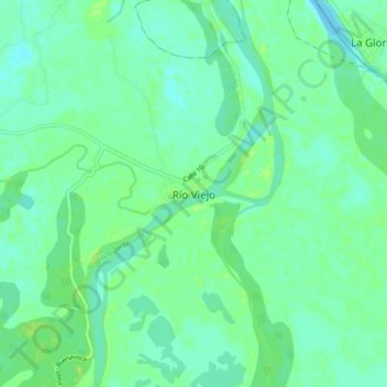
Name: Río Viejo topographic map, elevation, terrain.
Location: Río Viejo, Bolívar, RAP Caribe, Colombia (8.54697 -73.87889 8.62697 -73.79889)
Average elevation: 115 ft
Minimum elevation: 95 ft
Maximum elevation: 141 ft
Make a donation
Gear up for your next adventure:
As an Amazon Associate, this site earns from qualifying purchases at no extra cost to you.