
Make a donation
Gear up for your next adventure:
As an Amazon Associate, this site earns from qualifying purchases at no extra cost to you.
Pico Zapatero topographic map
Click on the map to display elevation.
Make a donation
Gear up for your next adventure:
As an Amazon Associate, this site earns from qualifying purchases at no extra cost to you.
Pico Zapatero
La topografía de la Sierra de la Paramera es fundamentalmente plana, de cumbres alomadas, menos en el sector culminante, donde varios picos superan los 2000 m.
Make a donation
Gear up for your next adventure:
As an Amazon Associate, this site earns from qualifying purchases at no extra cost to you.
About this map
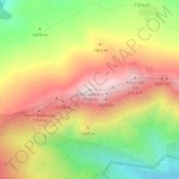
Name: Pico Zapatero topographic map, elevation, terrain.
Location: Pico Zapatero, Sotalbo, Ávila, Castilla y León, España (40.49210 -4.87030 40.49220 -4.87020)
Average elevation: 5,846 ft
Minimum elevation: 4,606 ft
Maximum elevation: 7,005 ft
Make a donation
Gear up for your next adventure:
As an Amazon Associate, this site earns from qualifying purchases at no extra cost to you.