
Thank you for supporting this site ❤️
Make a donation
Make a donation
Gear up for your next adventure:
As an Amazon Associate, this site earns from qualifying purchases at no extra cost to you.
Reinach topographic map
Click on the map to display elevation.
Thank you for supporting this site ❤️
Make a donation
Make a donation
Gear up for your next adventure:
As an Amazon Associate, this site earns from qualifying purchases at no extra cost to you.
About this map
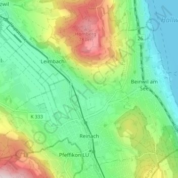
Name: Reinach topographic map, elevation, terrain.
Location: Reinach, Bezirk Kulm, Aargau, 5734, Switzerland (47.24552 8.14251 47.28540 8.20670)
Average elevation: 1,886 ft
Minimum elevation: 1,460 ft
Maximum elevation: 2,733 ft
Thank you for supporting this site ❤️
Make a donation
Make a donation
Gear up for your next adventure:
As an Amazon Associate, this site earns from qualifying purchases at no extra cost to you.