
Make a donation
Gear up for your next adventure:
As an Amazon Associate, this site earns from qualifying purchases at no extra cost to you.
Santol topographic map
Click on the map to display elevation.
Make a donation
Gear up for your next adventure:
As an Amazon Associate, this site earns from qualifying purchases at no extra cost to you.
About this map
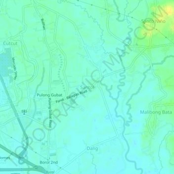
Name: Santol topographic map, elevation, terrain.
Location: Santol, Bulacan, Central Luzon, 3016, Philippines (14.83215 120.89404 14.87215 120.93404)
Average elevation: 26 ft
Minimum elevation: 7 ft
Maximum elevation: 72 ft
Make a donation
Gear up for your next adventure:
As an Amazon Associate, this site earns from qualifying purchases at no extra cost to you.
Other topographic maps
Click on a map to view its topography, its elevation and its terrain.
Marina Lake
Philippines > Bulacan > San Jose del Monte > Sapang Palay Proper
Average elevation: 164 ft
Biak na Bato National Park
Philippines > Bulacan > Doña Remedios Trinidad > Talbak
Average elevation: 417 ft
Make a donation
Gear up for your next adventure:
As an Amazon Associate, this site earns from qualifying purchases at no extra cost to you.
Doña Remedios Trinidad
List of highest peaks in D.R.T by elevation.
Average elevation: 564 ft