Geolocate

Clinton topographic map

Click on the map to display elevation.

About this map

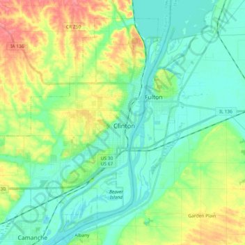
Name: Clinton topographic map, elevation, terrain.

Location: Clinton, Clinton County, Iowa, United States (41.79379 -90.34516 41.91017 -90.16233)

Average elevation: 646 ft

Minimum elevation: 561 ft

Maximum elevation: 833 ft

Other topographic maps

Click on a map to view its topography, its elevation and its terrain.

Nancy Elaine Lake

United States > Iowa > Clinton County > Camanche

Average elevation: 600 ft

Adams Island

United States > Iowa > Clinton County

Average elevation: 587 ft

Gear up for your next adventure:

📚Navigation Handbooks - Master the art of reading topographic maps and using a compass
🔌USB Car Charger - Car charger for on‑the‑go power needs
🔦LED Headlamp - Bright and durable LED headlamp for night navigation
🎒Day Hiking Backpack - Lightweight backpack perfect for day trips and outdoor adventures
🛰️Satellite Messengers - Emergency SOS and two-way messaging for off-grid adventures

As an Amazon Associate, this site earns from qualifying purchases at no extra cost to you.