Geolocate

Schladern topographic map

Click on the map to display elevation.

About this map

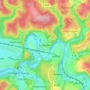
Name: Schladern topographic map, elevation, terrain.

Location: Schladern, Windeck, Rhein-Sieg-Kreis, North Rhine-Westphalia, 51570, Germany (50.79003 7.57338 50.83003 7.61338)

Average elevation: 604 ft

Minimum elevation: 341 ft

Maximum elevation: 1,007 ft

Gear up for your next adventure:

🛠️Backpacking Tool Kit - Essential toolkit for outdoor repairs
🥩Freeze-Dried Meals - Nutritious and lightweight food for remote expeditions
🕶️GPS Smartphone Mount - Secure mount for phone navigation
🎒Trekking Poles - Sturdy poles for balance and stability on rough terrain
🛶Inflatable Kayak - Portable kayak for rivers, lakes, and expeditions

As an Amazon Associate, this site earns from qualifying purchases at no extra cost to you.