Geolocate

Redmond topographic map

Click on the map to display elevation.

About this map

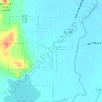
Name: Redmond topographic map, elevation, terrain.

Location: Redmond, Sevier County, Utah, 84652, United States (38.99582 -111.88057 39.01436 -111.85433)

Average elevation: 5,125 ft

Minimum elevation: 5,092 ft

Maximum elevation: 5,325 ft

Sevier County trails, hiking, mountain biking, running and outdoor activities

Other topographic maps

Click on a map to view its topography, its elevation and its terrain.

Monroe Peak

United States > Utah > Sevier County

Average elevation: 10,302 ft

Sawtooth

United States > Utah > Sevier County

Average elevation: 6,788 ft

Austin

United States > Utah > Sevier County

Average elevation: 5,328 ft

Gear up for your next adventure:

🧢Outdoor Hiking Hat - Sun protection hat for outdoor explorers
🔋Solar Power Banks - Keep your GPS and phone charged in remote wilderness areas
🪶Multi‑Purpose Knife - Useful blade for camp and trail
🏫Relief Map Kits - Hands-on tools for teaching landforms and elevation
🪑Portable Camp Table - Compact table for campsite meals

As an Amazon Associate, this site earns from qualifying purchases at no extra cost to you.