
Thank you for supporting this site ❤️
Make a donation
Make a donation
Gear up for your next adventure:
As an Amazon Associate, this site earns from qualifying purchases at no extra cost to you.
Cardes topographic map
Click on the map to display elevation.
Thank you for supporting this site ❤️
Make a donation
Make a donation
Gear up for your next adventure:
As an Amazon Associate, this site earns from qualifying purchases at no extra cost to you.
About this map
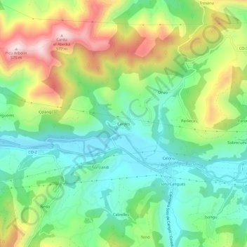
Name: Cardes topographic map, elevation, terrain.
Location: Cardes, Cangas de Onís, Asturias, 33589, España (43.33458 -5.11443 43.37458 -5.07443)
Average elevation: 781 ft
Minimum elevation: 207 ft
Maximum elevation: 1,798 ft
Thank you for supporting this site ❤️
Make a donation
Make a donation
Gear up for your next adventure:
As an Amazon Associate, this site earns from qualifying purchases at no extra cost to you.