
White Hall topographic map
Click on the map to display elevation.
About this map
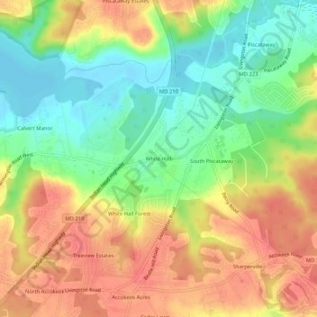
Name: White Hall topographic map, elevation, terrain.
Average elevation: 118 ft
Minimum elevation: -7 ft
Maximum elevation: 236 ft
Prince George's County trails, hiking, mountain biking, running and outdoor activities
Other topographic maps
Click on a map to view its topography, its elevation and its terrain.
Accokeek
United States > Maryland > Prince George's County > Accokeek
According to the United States Census Bureau, the place has a total area of 28.803 square miles (74.60 km2), of which 27.436 square miles (71.06 km2) is land and 1.367 square miles (3.54 km2) is water. Accokeek has an average elevation of 194 feet (59 m).
Average elevation: 151 ft