
Thank you for supporting this site ❤️
Make a donation
Make a donation
Gear up for your next adventure:
As an Amazon Associate, this site earns from qualifying purchases at no extra cost to you.
Koynanagar topographic map
Click on the map to display elevation.
Thank you for supporting this site ❤️
Make a donation
Make a donation
Gear up for your next adventure:
As an Amazon Associate, this site earns from qualifying purchases at no extra cost to you.
About this map
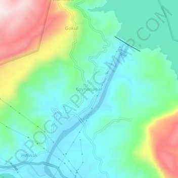
Name: Koynanagar topographic map, elevation, terrain.
Location: Koynanagar, Patan, Satara, Maharashtra, 415207, India (17.37198 73.72223 17.41198 73.76223)
Average elevation: 2,320 ft
Minimum elevation: 1,883 ft
Maximum elevation: 3,399 ft
Thank you for supporting this site ❤️
Make a donation
Make a donation
Gear up for your next adventure:
As an Amazon Associate, this site earns from qualifying purchases at no extra cost to you.