
Make a donation
Gear up for your next adventure:
As an Amazon Associate, this site earns from qualifying purchases at no extra cost to you.
Kariega River topographic map
Click on the map to display elevation.
Make a donation
Gear up for your next adventure:
As an Amazon Associate, this site earns from qualifying purchases at no extra cost to you.
About this map
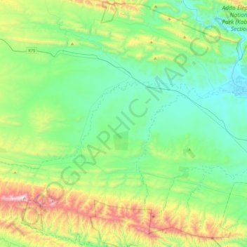
Name: Kariega River topographic map, elevation, terrain.
Average elevation: 1,430 ft
Minimum elevation: 358 ft
Maximum elevation: 4,541 ft
Make a donation
Gear up for your next adventure:
As an Amazon Associate, this site earns from qualifying purchases at no extra cost to you.
Other topographic maps
Click on a map to view its topography, its elevation and its terrain.
Bloemhof Dam
South Africa > Eastern Cape > Sarah Baartman District Municipality > Camdeboo Local Municipality
Average elevation: 3,780 ft
Oyster Bay Wind Farm
South Africa > Eastern Cape > Sarah Baartman District Municipality > Kouga Local Municipality
Average elevation: 459 ft
Oyster Bay
South Africa > Eastern Cape > Sarah Baartman District Municipality > Kouga Local Municipality
Average elevation: 92 ft
Make a donation
Gear up for your next adventure:
As an Amazon Associate, this site earns from qualifying purchases at no extra cost to you.
Riet River
South Africa > Eastern Cape > Sarah Baartman District Municipality > Ikwezi Local Municipality
Average elevation: 1,588 ft
Cape St. Francis
South Africa > Eastern Cape > Sarah Baartman District Municipality > Kouga Local Municipality
Average elevation: 33 ft
Sundays River
South Africa > Eastern Cape > Sarah Baartman District Municipality > Sundays River Valley Local Municipality
Average elevation: 89 ft
Kirkwood
South Africa > Eastern Cape > Sarah Baartman District Municipality > Sundays River Valley Local Municipality
Average elevation: 594 ft
Make a donation
Gear up for your next adventure:
As an Amazon Associate, this site earns from qualifying purchases at no extra cost to you.
Addo Elephant Park (Nyati Section)
South Africa > Eastern Cape > Sarah Baartman District Municipality > Sundays River Valley Local Municipality
Average elevation: 1,194 ft
Alicedale
South Africa > Eastern Cape > Sarah Baartman District Municipality > Makana Local Municipality > Alicedale
Average elevation: 1,312 ft
Paradise Beach
South Africa > Eastern Cape > Sarah Baartman District Municipality > Kouga Local Municipality
Average elevation: 23 ft
Alexandria
South Africa > Eastern Cape > Sarah Baartman District Municipality > Ndlambe Local Municipality
Average elevation: 597 ft
Make a donation
Gear up for your next adventure:
As an Amazon Associate, this site earns from qualifying purchases at no extra cost to you.
Witrivier
South Africa > Eastern Cape > Sarah Baartman District Municipality > Sundays River Valley Local Municipality
Average elevation: 1,106 ft
Valley of Desolation
South Africa > Eastern Cape > Sarah Baartman District Municipality > Camdeboo Local Municipality
Average elevation: 3,583 ft
Oubosstrand
South Africa > Eastern Cape > Sarah Baartman District Municipality > Kou-Kamma Local Municipality
Average elevation: 223 ft
Waboomsrivier
South Africa > Eastern Cape > Sarah Baartman District Municipality > Kou-Kamma Local Municipality > Joubertina
Average elevation: 1,834 ft
Make a donation
Gear up for your next adventure:
As an Amazon Associate, this site earns from qualifying purchases at no extra cost to you.
Map Position 36
South Africa > Eastern Cape > Sarah Baartman District Municipality > Sundays River Valley Local Municipality > Matyholweni Camp
Average elevation: 187 ft
Cookhouse
South Africa > Eastern Cape > Sarah Baartman District Municipality > Blue Crane Route Local Municipality
Average elevation: 2,195 ft
KwaNojoli
South Africa > Eastern Cape > Sarah Baartman District Municipality > Blue Crane Route Local Municipality
Average elevation: 3,094 ft
Rooidam
South Africa > Eastern Cape > Sarah Baartman District Municipality > Sundays River Valley Local Municipality
Average elevation: 571 ft
Make a donation
Gear up for your next adventure:
As an Amazon Associate, this site earns from qualifying purchases at no extra cost to you.
Steytlerville
South Africa > Eastern Cape > Sarah Baartman District Municipality > Baviaans Local Municipality
Average elevation: 1,555 ft
Witrivier
South Africa > Eastern Cape > Sarah Baartman District Municipality > Sundays River Valley Local Municipality
Average elevation: 240 ft
Twee Riviere
South Africa > Eastern Cape > Sarah Baartman District Municipality > Kou-Kamma Local Municipality
Average elevation: 1,886 ft
Storm River
South Africa > Eastern Cape > Sarah Baartman District Municipality > Kou-Kamma Local Municipality > Storms River Mouth Rest Camp
Average elevation: 318 ft
Make a donation
Gear up for your next adventure:
As an Amazon Associate, this site earns from qualifying purchases at no extra cost to you.
East Beach
South Africa > Eastern Cape > Sarah Baartman District Municipality > Ndlambe Local Municipality > Port Alfred
Average elevation: 49 ft
Krakeelrivier
South Africa > Eastern Cape > Sarah Baartman District Municipality > Kou-Kamma Local Municipality > Krakeelrivier
Average elevation: 2,051 ft
Soutrivier
South Africa > Eastern Cape > Sarah Baartman District Municipality > Camdeboo Local Municipality
Average elevation: 2,244 ft