Geolocate

Mpanda topographic map

Click on the map to display elevation.

About this map

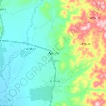
Name: Mpanda topographic map, elevation, terrain.

Location: Mpanda, Bubanza, Burundi (-3.20928 29.36471 -3.12928 29.44471)

Average elevation: 3,074 ft

Minimum elevation: 2,703 ft

Maximum elevation: 4,039 ft

Gear up for your next adventure:

👟Men's Trail Runners - Lightweight footwear for fast-paced exploration and light hiking
🪵Folding Camp Saw - Compact saw for wood and campsite work
🪶Paracord Bracelet - Survival bracelet with built‑in tools
Backpacking Tents - Weight-optimized shelters for multi-day topographic surveys
❄️Traction Cleats - Prevent slips on icy trails during winter hikes

As an Amazon Associate, this site earns from qualifying purchases at no extra cost to you.