
Make a donation
Gear up for your next adventure:
As an Amazon Associate, this site earns from qualifying purchases at no extra cost to you.
Santiago topographic map
Click on the map to display elevation.
Make a donation
Gear up for your next adventure:
As an Amazon Associate, this site earns from qualifying purchases at no extra cost to you.
Santiago
Santiago (Spanish meaning Saint James) is a municipality of the western part of the state of Rio Grande do Sul, Brazil. It is the capital of the microregion of Santiago. The population is 49,360 (2020 est.) in an area of 2,413.13 km2 (931.71 sq mi). Its elevation is 409 m. It is located 450 km west of the state capital of Porto Alegre and northeast of Alegrete. The nickname of the city is "The Land of the Poets".
Make a donation
Gear up for your next adventure:
As an Amazon Associate, this site earns from qualifying purchases at no extra cost to you.
About this map
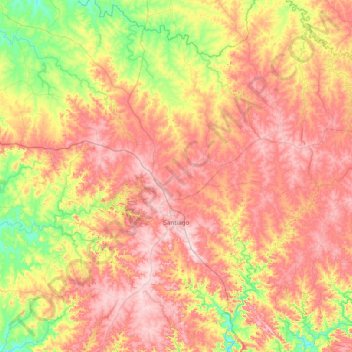
Name: Santiago topographic map, elevation, terrain.
Average elevation: 912 ft
Minimum elevation: 354 ft
Maximum elevation: 1,476 ft
Make a donation
Gear up for your next adventure:
As an Amazon Associate, this site earns from qualifying purchases at no extra cost to you.
Other topographic maps
Click on a map to view its topography, its elevation and its terrain.
Quarto Frio
Brazil > Rio Grande do Sul > Metropolitan Region of Porto Alegre > Taquara
Average elevation: 866 ft
Taquaruçu
Brazil > Rio Grande do Sul > Aglomeração Urbana do Litoral Norte > Mampituba
Average elevation: 709 ft
Make a donation
Gear up for your next adventure:
As an Amazon Associate, this site earns from qualifying purchases at no extra cost to you.
Make a donation
Gear up for your next adventure:
As an Amazon Associate, this site earns from qualifying purchases at no extra cost to you.
Pelotas
Brazil > Rio Grande do Sul > Aglomeração Urbana do Sul > Pelotas
As it is situated on a plain near the ocean, the urban area lies on a low elevation, being, on average, 7 meters (23 ft) above sea level. The interior of the municipality is on a plateau called Serras de Sudeste (Southeastern Mountain Ranges). Consequently, the altitude in Pelotas' rural area reaches 429…
Average elevation: 59 ft
Praça
Brazil > Rio Grande do Sul > Metropolitan Region of Porto Alegre > Porto Alegre
Average elevation: 49 ft
Make a donation
Gear up for your next adventure:
As an Amazon Associate, this site earns from qualifying purchases at no extra cost to you.