Geolocate

Butternut topographic map

Click on the map to display elevation.

About this map

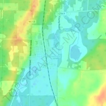
Name: Butternut topographic map, elevation, terrain.

Location: Butternut, Ashland County, Wisconsin, United States (46.00294 -90.50954 46.02472 -90.48781)

Average elevation: 1,529 ft

Minimum elevation: 1,486 ft

Maximum elevation: 1,604 ft

Ashland County trails, hiking, mountain biking, running and outdoor activities

Other topographic maps

Click on a map to view its topography, its elevation and its terrain.

La Pointe

United States > Wisconsin > Ashland County

Average elevation: 610 ft

Highbridge

United States > Wisconsin > Ashland County

Average elevation: 968 ft

Glidden

United States > Wisconsin > Ashland County

Average elevation: 1,535 ft

Morgan Falls

United States > Wisconsin > Ashland County

Average elevation: 1,319 ft

Marengo

United States > Wisconsin > Ashland County

Average elevation: 787 ft

Gear up for your next adventure:

🛰️Handheld GPS Units - Professional satellite navigators for precise backcountry mapping
🗺️Topographic Maps - Detailed topo maps for hiking, exploring and outdoor navigation
🔦LED Headlamp - Bright and durable LED headlamp for night navigation
🎒Gear Packing Cubes - Organize your backpack efficiently
🪵Folding Camp Saw - Compact saw for wood and campsite work

As an Amazon Associate, this site earns from qualifying purchases at no extra cost to you.