
Thank you for supporting this site ❤️
Make a donation
Make a donation
Gear up for your next adventure:
As an Amazon Associate, this site earns from qualifying purchases at no extra cost to you.
Mapoteng topographic map
Click on the map to display elevation.
Thank you for supporting this site ❤️
Make a donation
Make a donation
Gear up for your next adventure:
As an Amazon Associate, this site earns from qualifying purchases at no extra cost to you.
About this map
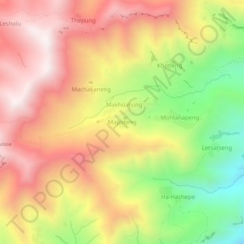
Name: Mapoteng topographic map, elevation, terrain.
Location: Mapoteng, Thaba-Tseka District, Lesotho (-29.44851 28.73278 -29.40851 28.77278)
Average elevation: 7,963 ft
Minimum elevation: 6,257 ft
Maximum elevation: 9,331 ft
Thank you for supporting this site ❤️
Make a donation
Make a donation
Gear up for your next adventure:
As an Amazon Associate, this site earns from qualifying purchases at no extra cost to you.