
Gemeinde Baden topographic map
Interactive map
Click on the map to display elevation.
About this map
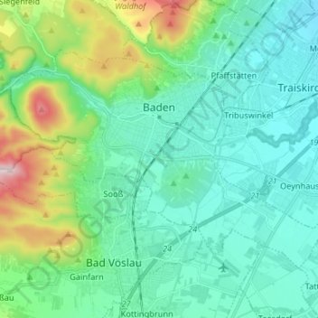
Name: Gemeinde Baden topographic map, elevation, terrain.
Location: Gemeinde Baden, Bezirk Baden, Lower Austria, Austria (47.96386 16.17203 48.02450 16.30320)
Average elevation: 945 ft
Minimum elevation: 623 ft
Maximum elevation: 2,139 ft
Other topographic maps
Click on a map to view its topography, its elevation and its terrain.
Gemeinde Sooß
Austria > Lower Austria > Bezirk Baden
Gemeinde Sooß, Bezirk Baden, Lower Austria, 2504, Austria
Average elevation: 981 ft