
Gemeinde Sooß topographic map
Interactive map
Click on the map to display elevation.
About this map
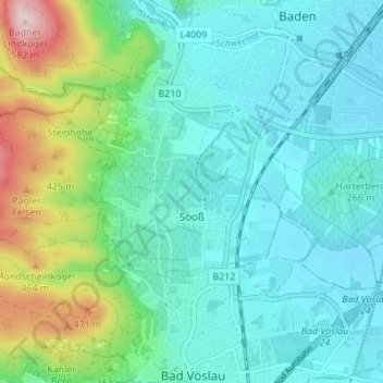
Name: Gemeinde Sooß topographic map, elevation, terrain.
Location: Gemeinde Sooß, Bezirk Baden, Lower Austria, 2504, Austria (47.97746 16.16212 47.99747 16.23061)
Average elevation: 981 ft
Minimum elevation: 728 ft
Maximum elevation: 1,877 ft
Other topographic maps
Click on a map to view its topography, its elevation and its terrain.
Gemeinde Baden
Austria > Lower Austria > Bezirk Baden
Gemeinde Baden, Bezirk Baden, Lower Austria, Austria
Average elevation: 945 ft