
Make a donation
Gear up for your next adventure:
As an Amazon Associate, this site earns from qualifying purchases at no extra cost to you.
Six Mile Cove topographic map
Click on the map to display elevation.
Make a donation
Gear up for your next adventure:
As an Amazon Associate, this site earns from qualifying purchases at no extra cost to you.
About this map
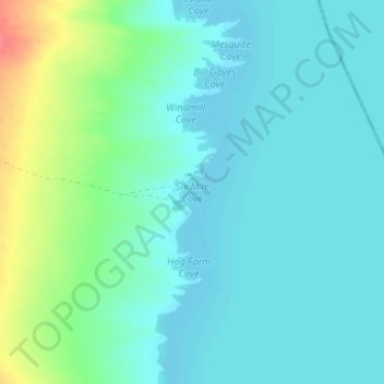
Name: Six Mile Cove topographic map, elevation, terrain.
Location: Six Mile Cove, Clark County, Nevada, United States (35.45300 -114.67808 35.45310 -114.67798)
Average elevation: 682 ft
Minimum elevation: 636 ft
Maximum elevation: 837 ft
Make a donation
Gear up for your next adventure:
As an Amazon Associate, this site earns from qualifying purchases at no extra cost to you.
Other topographic maps
Click on a map to view its topography, its elevation and its terrain.
Cougar Creek Park
United States > Nevada > Clark County > Las Vegas > Enterprise
Average elevation: 2,530 ft
Blue Diamond
United States > Nevada > Clark County
Blue Diamond is the site of Cottonwood Spring (formerly known as Ojo de Cayetana, or Pearl Spring), a watering place and camp site on the Old Spanish Trail and the later Mormon Road between Mountain Springs and Las Vegas Springs. The springs are located on a mountainside south of the town at 36°02′44″N…
Average elevation: 3,642 ft
Make a donation
Gear up for your next adventure:
As an Amazon Associate, this site earns from qualifying purchases at no extra cost to you.