
Make a donation
Gear up for your next adventure:
As an Amazon Associate, this site earns from qualifying purchases at no extra cost to you.
Greene Township topographic map
Click on the map to display elevation.
Make a donation
Gear up for your next adventure:
As an Amazon Associate, this site earns from qualifying purchases at no extra cost to you.
About this map
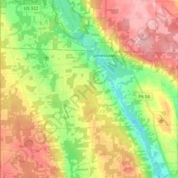
Name: Greene Township topographic map, elevation, terrain.
Location: Greene Township, Mercer County, Pennsylvania, United States (41.44073 -80.51926 41.48908 -80.38007)
Average elevation: 1,138 ft
Minimum elevation: 942 ft
Maximum elevation: 1,355 ft
Mercer County trails, hiking, mountain biking, running and outdoor activities
Make a donation
Gear up for your next adventure:
As an Amazon Associate, this site earns from qualifying purchases at no extra cost to you.
Other topographic maps
Click on a map to view its topography, its elevation and its terrain.
Jackson Township
United States > Pennsylvania > Mercer County > Jackson Township
Average elevation: 1,266 ft
Greencrest Park
United States > Pennsylvania > Mercer County > Pymatuning Township
Average elevation: 1,017 ft
Make a donation
Gear up for your next adventure:
As an Amazon Associate, this site earns from qualifying purchases at no extra cost to you.