Geolocate

Cardona topographic map

Click on the map to display elevation.

About this map

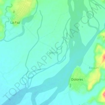
Name: Cardona topographic map, elevation, terrain.

Location: Cardona, Abra, Cordillera Administrative Region, 2801, Philippines (17.63932 120.67882 17.67932 120.71882)

Average elevation: 210 ft

Minimum elevation: 161 ft

Maximum elevation: 400 ft

Other topographic maps

Click on a map to view its topography, its elevation and its terrain.

Peñarrubia

Philippines > Abra

Average elevation: 400 ft

Abra River

Philippines > Abra > Pidigan

Average elevation: 390 ft

Utip River

Philippines > Abra > Tubo

Average elevation: 2,188 ft

Malanas River

Philippines > Abra > San Juan > Badas

Average elevation: 417 ft

Ikmin River

Philippines > Abra

Average elevation: 2,333 ft

Gear up for your next adventure:

🧥Waterproof Jacket for Hiking - Breathable and rugged rain jacket for outdoor excursions
📦Dry Bags Set - Waterproof storage for electronics and clothes
🎒Outdoor Daypacks - Lightweight backpacks designed for carrying maps and essential gear
📱Heavy-Duty Phone Cases - Drop-proof and waterproof protection for outdoor navigation
🧤Tactile Hiking Gloves - Keep hands warm while operating GPS and smartphone screens

As an Amazon Associate, this site earns from qualifying purchases at no extra cost to you.