
Thank you for supporting this site ❤️
Make a donation
Make a donation
Gear up for your next adventure:
As an Amazon Associate, this site earns from qualifying purchases at no extra cost to you.
Qarabagh topographic map
Click on the map to display elevation.
Thank you for supporting this site ❤️
Make a donation
Make a donation
Gear up for your next adventure:
As an Amazon Associate, this site earns from qualifying purchases at no extra cost to you.
About this map
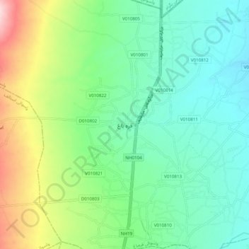
Name: Qarabagh topographic map, elevation, terrain.
Location: Qarabagh, Kabul Province, Afghanistan (34.80295 69.11188 34.88295 69.19188)
Average elevation: 5,171 ft
Minimum elevation: 4,934 ft
Maximum elevation: 5,758 ft
Thank you for supporting this site ❤️
Make a donation
Make a donation
Gear up for your next adventure:
As an Amazon Associate, this site earns from qualifying purchases at no extra cost to you.