
Make a donation
Gear up for your next adventure:
As an Amazon Associate, this site earns from qualifying purchases at no extra cost to you.
Manrode topographic map
Click on the map to display elevation.
Make a donation
Gear up for your next adventure:
As an Amazon Associate, this site earns from qualifying purchases at no extra cost to you.
About this map
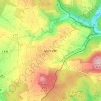
Name: Manrode topographic map, elevation, terrain.
Average elevation: 886 ft
Minimum elevation: 499 ft
Maximum elevation: 1,257 ft
Make a donation
Gear up for your next adventure:
As an Amazon Associate, this site earns from qualifying purchases at no extra cost to you.
Other topographic maps
Click on a map to view its topography, its elevation and its terrain.
Borgholz
Deutschland > Nordrhein-Westfalen > Kreis Höxter > Borgentreich
An einem nach drei Seiten hin abfallenden Ausläufer eines noch im 14. Jahrhundert gerodeten Höhenrückens nordöstlich von Borgentreich liegt die ehemalige Stadt Borgholz. Sie wird erstmals 1291 genannt – gleich zwei urkundliche Nachrichten belegen, dass es Borcholte zu dieser Zeit bereits gab. Sie…
Average elevation: 791 ft
Manrode
Deutschland > Nordrhein-Westfalen > Kreis Höxter > Borgentreich > Manrode
Average elevation: 886 ft
Natzungen
Deutschland > Nordrhein-Westfalen > Kreis Höxter > Borgentreich > Natzungen
Average elevation: 807 ft
Make a donation
Gear up for your next adventure:
As an Amazon Associate, this site earns from qualifying purchases at no extra cost to you.