
Saint-Lambert topographic map
Click on the map to display elevation.
About this map
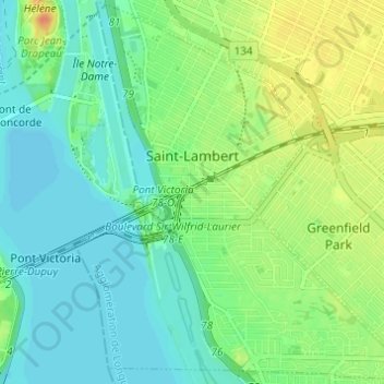
Name: Saint-Lambert topographic map, elevation, terrain.
Average elevation: 56 ft
Minimum elevation: 13 ft
Maximum elevation: 135 ft
Other topographic maps
Click on a map to view its topography, its elevation and its terrain.
Parc des Pâquerettes
Canada > Québec > Agglomération de Longueuil > Longueuil
Average elevation: 79 ft
Mont Saint-Bruno
Canada > Québec > Agglomération de Longueuil > Saint-Bruno-de-Montarville
Average elevation: 279 ft
Parc du Frère-Marcel-Alary
Canada > Québec > Agglomération de Longueuil > Saint-Bruno-de-Montarville
Average elevation: 226 ft
Longueuil
Canada > Québec > Agglomération de Longueuil
Longueuil est situé dans les basses-terres du Saint-Laurent, une plaine de faible altitude avec très peu de relief. Aucune des collines locales, les Montérégiennes, ne se trouve sur son territoire. L'altitude minimale est de 4 mètres, au fleuve Saint-Laurent. Elle augmente jusqu'à une vingtaine de…
Average elevation: 95 ft