Geolocate

Calway topographic map

Interactive map

Click on the map to display elevation.

About this map

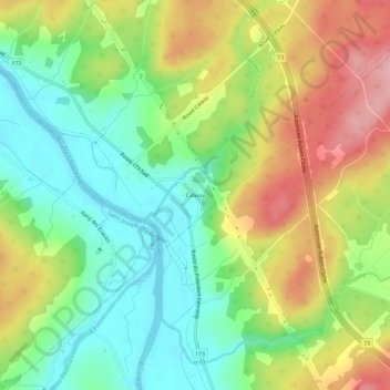
Name: Calway topographic map, elevation, terrain.

Location: Calway, Saint-Joseph-de-Beauce, Beauce-Centre, Chaudière-Appalaches, Québec, Canada (46.25244 -70.83892 46.29244 -70.79892)

Average elevation: 653 ft

Minimum elevation: 449 ft

Maximum elevation: 938 ft

Other topographic maps

Click on a map to view its topography, its elevation and its terrain.

Rivière Pouliot

Canada > Québec > Beauce-Centre > Saint-Joseph-de-Beauce

Rivière Pouliot, Saint-Joseph-de-Beauce, Beauce-Centre, Chaudière-Appalaches, Québec, Canada

Average elevation: 869 ft

Ruisseau Saints-Anges

Canada > Québec > Beauce-Centre > Saint-Joseph-de-Beauce

Ruisseau Saints-Anges, Saint-Joseph-de-Beauce, Beauce-Centre, Chaudière-Appalaches, Québec, G0S 2V0, Canada

Average elevation: 886 ft