
Make a donation
Gear up for your next adventure:
As an Amazon Associate, this site earns from qualifying purchases at no extra cost to you.
Viqueque topographic map
Click on the map to display elevation.
Make a donation
Gear up for your next adventure:
As an Amazon Associate, this site earns from qualifying purchases at no extra cost to you.
About this map
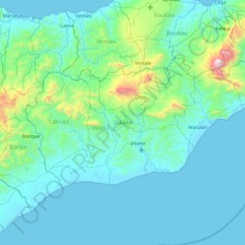
Name: Viqueque topographic map, elevation, terrain.
Location: Viqueque, East Timor (-8.99087 126.04620 -8.62825 126.73764)
Average elevation: 778 ft
Minimum elevation: -3 ft
Maximum elevation: 7,562 ft
Make a donation
Gear up for your next adventure:
As an Amazon Associate, this site earns from qualifying purchases at no extra cost to you.
Other topographic maps
Click on a map to view its topography, its elevation and its terrain.
Pante Macassar
East Timor > Oecussi-Ambeno > Oecussi-Ambeno > Pante Macassar
Average elevation: 472 ft
Dili
The main city lies within an area of flat lowlands of less than 100m altitude, mostly between 0 and 60m, and a slope under 15 degrees. This includes an alluvial plain, and a number of beaches line the coast. The soil underneath this plain is quaternary alluvium. The distance between the sea and the mountains…
Average elevation: 1,106 ft
Make a donation
Gear up for your next adventure:
As an Amazon Associate, this site earns from qualifying purchases at no extra cost to you.