Geolocate

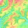
Lambertsberg topographic map

Click on the map to display elevation.

About this map

Name: Lambertsberg topographic map, elevation, terrain.

Location: Lambertsberg, Arzfeld, Eifelkreis Bitburg-Prüm, Rijnland-Palts, Duitsland (50.07697 6.38011 50.10104 6.41231)

Average elevation: 1,473 ft

Minimum elevation: 1,017 ft

Maximum elevation: 1,795 ft

Other topographic maps

Click on a map to view its topography, its elevation and its terrain.

Buscht

Duitsland > Rijnland-Palts > Eifelkreis Bitburg-Prüm

Average elevation: 1,234 ft

Gear up for your next adventure:

🧣Hiking Neck Gaiter - Multi‑use neck protection for outdoor weather
🔦Compact Flashlight - Reliable flashlight for emergencies
🎒Hydration Pack - Hands‑free water reservoir for long hikes
🥾Hiking Shoes - Durable and comfortable shoes for trail hiking
🧷Carabiner Set - Durable clips for gear attachment

As an Amazon Associate, this site earns from qualifying purchases at no extra cost to you.