
Make a donation
Gear up for your next adventure:
As an Amazon Associate, this site earns from qualifying purchases at no extra cost to you.
Elm topographic map
Click on the map to display elevation.
Make a donation
Gear up for your next adventure:
As an Amazon Associate, this site earns from qualifying purchases at no extra cost to you.
About this map
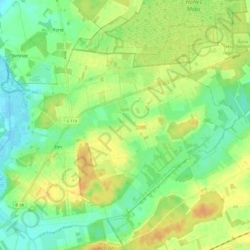
Name: Elm topographic map, elevation, terrain.
Average elevation: 49 ft
Minimum elevation: -3 ft
Maximum elevation: 105 ft
Make a donation
Gear up for your next adventure:
As an Amazon Associate, this site earns from qualifying purchases at no extra cost to you.
Other topographic maps
Click on a map to view its topography, its elevation and its terrain.
Hesedorf
Deutschland > Niedersachsen > Landkreis Rotenburg (Wümme) > Bremervörde
Average elevation: 59 ft
Nieder Ochtenhausen
Deutschland > Niedersachsen > Landkreis Rotenburg (Wümme) > Bremervörde
Average elevation: 16 ft
Ottendorf
Deutschland > Niedersachsen > Landkreis Rotenburg (Wümme) > Bremervörde
Average elevation: 7 ft
Hönau-Lindorf
Deutschland > Niedersachsen > Landkreis Rotenburg (Wümme) > Bremervörde > Hönau-Lindorf
Average elevation: 13 ft
Make a donation
Gear up for your next adventure:
As an Amazon Associate, this site earns from qualifying purchases at no extra cost to you.
Iselersheim
Deutschland > Niedersachsen > Landkreis Rotenburg (Wümme) > Bremervörde
Average elevation: 7 ft