Geolocate

Karimpur topographic map

Click on the map to display elevation.

Karimpur

Karimpur is located at 23°58′N 88°37′E / 23.97°N 88.62°E / 23.97; 88.62. It has an average elevation of 15 metres (49 ft). It is 183 km (114 mi) from Kolkata and is located at the bank of the River Jalangi.

Wikipedia (CC-BY-SA 3.0)

About this map

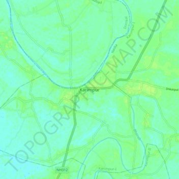
Name: Karimpur topographic map, elevation, terrain.

Location: Karimpur, Karimpur-I, Nadia, West Bengal, 741152, India (23.94160 88.58961 24.02160 88.66961)

Average elevation: 59 ft

Minimum elevation: 43 ft

Maximum elevation: 79 ft

Gear up for your next adventure:

🗻Climbing Gear Basics - Essential gear for beginner climbers
🔌USB Car Charger - Car charger for on‑the‑go power needs
🌡️Handheld Weather Meters - Measure wind, temp, and pressure for safe mountain travel
🦟Ultrasonic Repellers - Create a bug-free zone at your camp or rest stop
🗺️NatGeo Topo Maps - High-quality waterproof printed topographic maps of US Parks

As an Amazon Associate, this site earns from qualifying purchases at no extra cost to you.