
Crescent Meadow topographic map
Click on the map to display elevation.
About this map
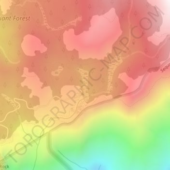
Name: Crescent Meadow topographic map, elevation, terrain.
Location: Crescent Meadow, Tulare County, California, United States (36.55362 -118.74970 36.55904 -118.74721)
Average elevation: 6,585 ft
Minimum elevation: 4,606 ft
Maximum elevation: 7,822 ft
Tulare County trails, hiking, mountain biking, running and outdoor activities
Other topographic maps
Click on a map to view its topography, its elevation and its terrain.
Porterville
United States > California > Tulare County
Porterville, lying along the foothills of the Sierras at an elevation of 455 feet (139 m), is located on State Highway 65, 165 miles (266 km) north of Los Angeles, and 171 miles (275 km) east of the Pacific Coast. The city has a strategic central location to major markets and a ready access to major…
Average elevation: 574 ft
Sequoia National Park
United States > California > Tulare County
Many park visitors enter Sequoia National Park through its southern entrance near the town of Three Rivers at Ash Mountain at 1,700 ft (520 m) elevation. The lower elevations around Ash Mountain contain the only National Park Service-protected California Foothills ecosystem, consisting of blue oak woodlands,…
Average elevation: 8,251 ft
Kennedy Meadows
United States > California > Tulare County
The Kennedy Meadows area is at approximately 6200 feet elevation. The most common access route is by the steep Sherman Pass Road from U.S. Route 395 near Pearsonville. Other routes are possible but much slower.
Average elevation: 6,535 ft
Dinuba
United States > California > Tulare County
According to the United States Census Bureau, the city has a total area of 6.5 square miles (17 km2), all of it land. The general topography is quite level ground, at an elevation of approximately 345 feet (105 m) above mean sea datum. The gradient is approximately ten feet per mile, from east-northeast to…
Average elevation: 351 ft
Mountain Home Demonstration State Forest
United States > California > Tulare County
Average elevation: 6,102 ft
Mount Whitney
United States > California > Tulare County
Mount Whitney (Paiute: Tumanguya; Too-man-i-goo-yah) is the highest mountain in the contiguous United States and the Sierra Nevada, with an elevation of 14,505 feet (4,421 m). It is in East–Central California, on the boundary between California's Inyo and Tulare counties, 84.6 miles (136.2 km) west-northwest…
Average elevation: 12,805 ft
Mount Whitney
United States > California > Tulare County
Mount Whitney (Paiute: Too-man-i-goo-yah or Too-man-go-yah) is the highest mountain in the contiguous United States, with an elevation of 14,505 feet (4,421 m). It is in East–Central California, in the Sierra Nevada, on the boundary between California's Inyo and Tulare counties, and 84.6 miles (136.2 km)…
Average elevation: 12,805 ft
Sequoia National Park
United States > California > Tulare County
Many park visitors enter Sequoia National Park through its southern entrance near the town of Three Rivers at Ash Mountain at 1,700 ft (520 m) elevation. The lower elevations around Ash Mountain contain the only National Park Service-protected California Foothills ecosystem, consisting of blue oak woodlands,…
Average elevation: 8,251 ft
Porterville
United States > California > Tulare County
Porterville, lying along the foothills of the Sierras at an elevation of 455 feet (139 m), is located on State Highway 65, 165 miles (266 km) north of Los Angeles, and 171 miles (275 km) east of the Pacific Coast. The city has a strategic central location to major markets and a ready access to major…
Average elevation: 574 ft
Sequoia National Park
United States > California > Tulare County
Many park visitors enter Sequoia National Park through its southern entrance near the town of Three Rivers at Ash Mountain at 1,700 ft (520 m) elevation. The lower elevations around Ash Mountain contain the only National Park Service-protected California Foothills ecosystem, consisting of blue oak woodlands,…
Average elevation: 8,251 ft
Allensworth
United States > California > Tulare County
Allensworth sits at an elevation of 213 feet (65 m), the same elevation as the huge and historically important Tulare Lake shore when it was full. The community is located in the ZIP Code 93219 and in the area code 661.
Average elevation: 207 ft
Porterville
United States > California > Tulare County
Porterville, lying along the foothills of the Sierras at an elevation of 455 feet (139 m), is located on State Highway 65, 165 miles (266 km) north of Los Angeles, and 171 miles (275 km) east of the Pacific Coast. The city has a strategic central location to major markets and a ready access to major…
Average elevation: 574 ft
Poplar
United States > California > Tulare County > Poplar-Cotton Center > Poplar
Average elevation: 377 ft