
Make a donation
Gear up for your next adventure:
As an Amazon Associate, this site earns from qualifying purchases at no extra cost to you.
Ponderosa topographic map
Click on the map to display elevation.
Make a donation
Gear up for your next adventure:
As an Amazon Associate, this site earns from qualifying purchases at no extra cost to you.
About this map
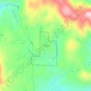
Name: Ponderosa topographic map, elevation, terrain.
Location: Ponderosa, Tulare County, California, United States (36.08550 -118.54814 36.12550 -118.50814)
Average elevation: 7,290 ft
Minimum elevation: 6,726 ft
Maximum elevation: 8,186 ft
Tulare County trails, hiking, mountain biking, running and outdoor activities
Make a donation
Gear up for your next adventure:
As an Amazon Associate, this site earns from qualifying purchases at no extra cost to you.
Other topographic maps
Click on a map to view its topography, its elevation and its terrain.
Sequoia National Park
United States > California > Tulare County
Many park visitors enter Sequoia National Park through its southern entrance near the town of Three Rivers at Ash Mountain at 1,700 ft (520 m) elevation. The lower elevations around Ash Mountain contain the only National Park Service-protected California Foothills ecosystem, consisting of blue oak woodlands,…
Average elevation: 8,251 ft
Porterville
United States > California > Tulare County
Porterville, lying along the foothills of the Sierras at an elevation of 455 feet (139 m), is located on State Highway 65, 165 miles (266 km) north of Los Angeles, and 171 miles (275 km) east of the Pacific Coast. The city has a strategic central location to major markets and a ready access to major…
Average elevation: 574 ft
Make a donation
Gear up for your next adventure:
As an Amazon Associate, this site earns from qualifying purchases at no extra cost to you.
Dinuba
United States > California > Tulare County
According to the United States Census Bureau, the city has a total area of 6.5 square miles (17 km2), all of it land. The general topography is quite level ground, at an elevation of approximately 345 feet (105 m) above mean sea datum. The gradient is approximately ten feet per mile, from east-northeast to…
Average elevation: 351 ft
Mountain Home Demonstration State Forest
United States > California > Tulare County
Average elevation: 6,102 ft
Make a donation
Gear up for your next adventure:
As an Amazon Associate, this site earns from qualifying purchases at no extra cost to you.
Kennedy Meadows
United States > California > Tulare County
The Kennedy Meadows area is at approximately 6200 feet elevation. The most common access route is by the steep Sherman Pass Road from U.S. Route 395 near Pearsonville. Other routes are possible but much slower.
Average elevation: 6,535 ft
Make a donation
Gear up for your next adventure:
As an Amazon Associate, this site earns from qualifying purchases at no extra cost to you.
Make a donation
Gear up for your next adventure:
As an Amazon Associate, this site earns from qualifying purchases at no extra cost to you.
Make a donation
Gear up for your next adventure:
As an Amazon Associate, this site earns from qualifying purchases at no extra cost to you.
Sequoia National Park
United States > California > Tulare County
Many park visitors enter Sequoia National Park through its southern entrance near the town of Three Rivers at Ash Mountain at 1,700 ft (520 m) elevation. The lower elevations around Ash Mountain contain the only National Park Service-protected California Foothills ecosystem, consisting of blue oak woodlands,…
Average elevation: 8,251 ft
Make a donation
Gear up for your next adventure:
As an Amazon Associate, this site earns from qualifying purchases at no extra cost to you.
Make a donation
Gear up for your next adventure:
As an Amazon Associate, this site earns from qualifying purchases at no extra cost to you.
Porterville
United States > California > Tulare County
Porterville, lying along the foothills of the Sierras at an elevation of 455 feet (139 m), is located on State Highway 65, 165 miles (266 km) north of Los Angeles, and 171 miles (275 km) east of the Pacific Coast. The city has a strategic central location to major markets and a ready access to major…
Average elevation: 574 ft
Make a donation
Gear up for your next adventure:
As an Amazon Associate, this site earns from qualifying purchases at no extra cost to you.
Make a donation
Gear up for your next adventure:
As an Amazon Associate, this site earns from qualifying purchases at no extra cost to you.
Make a donation
Gear up for your next adventure:
As an Amazon Associate, this site earns from qualifying purchases at no extra cost to you.